53k Trail Run Einsiedeln


- 11:25 h
- 55.24 km
- 3,006 m
- 2,985 m
- 890 m
- 1,849 m
- 959 m
- Start: Einsiedeln
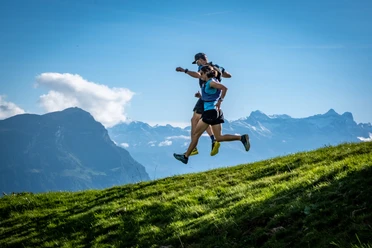
Flowing trails, beautiful panoramic views of the Schwyz mountain world, and a warm community are promised by the organizers of the "Trail Run Einsiedeln" held each autumn. The longest of the three routes, at 53 km, falls into the category of ultratrails. Only excellent fitness and strong willpower lead to the finish on this run, which goes over more than 10 peaks and up to the highest regions of Hoch Ybrig. Equally rewarding, but somewhat less demanding, are the two shorter rounds of 22 km and 13 km respectively. The routes are marked year-round with TRE signposts, so uncomplicated training is possible.

Good to know
Best to visit
Tour information
Loop Road
Stop at an Inn
Summit
Additional information
https://trail-maniacs.ch/trail-run-einsiedeln/strecken/
Literature
https://trail-maniacs.ch/trail-run-einsiedeln/strecken/
Author
Xaver Büeler
Organization
Schwyz Tourismus
License (master data)
Xaver Büeler
Author´s Tip / Recommendation of the author
Those who want to take it a bit easier will also find worthwhile shorter suggestions on the Trail Maniacs website.
Nearby
Download GPX file